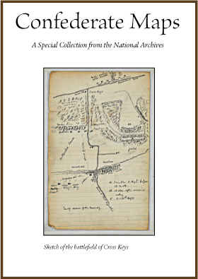
Confederate Map Series from the National Archives. (130+ maps). Maps played a very important role during the Civil War. They were instrumental to leaders and generals for planning battles, campaigns, and marches. These maps can include rough sketches created quickly before or during a battle, but can also include maps that were drawn to accompany official reports or even post-war publications. Many are highly detailed and colorized. Civil War maps frequently show topography, ground cover, roads, railroads, homes, the names of residents, towns, and waterways. They can be very helpful to better understand what the land looked like and how it was used during the Civil War era. Maps showing the names of residents can also be helpful to genealogists. The Civil War maps we are featuring today are all Confederate maps. These maps were captured by or surrendered to the United States at the conclusion of the Civil War, or were later donated by former Confederate leaders. The records were held by the War Department before coming to the National Archives. The maps cover areas in the states of Alabama, Arkansas, Georgia, Kentucky, Maryland, Mississippi, Missouri, Oklahoma (Indian Territory), South Carolina, Tennessee, Texas, and Virginia. Most of the maps are manuscripts, although some are printed maps or even copies of maps. Many of the printed maps are annotated to show troop movements, battles lines, or other important features. Many of the maps show well known battlefields and locations, such as Shiloh, Antietam, Murfreesboro (Stones River), Richmond, Petersburg, Atlanta, Knoxville, Manassas (Bull Run) and others. A number of maps show the battlefield at Shiloh, which was fought April 2-3, 1862 in southern Tennessee. Many maps also cover lesser known but also very important locations, such as Corinth, Mississippi, the location of a strategic railroad junction and site of a siege and battle. Other lesser known battles with maps in the series include Cross Keys, VA, Prairie Grove, AR, and scores of others. The series also includes maps and plans of fortifications, including those that protected Charleston, South Carolina, Vicksburg, Mississippi, and Beaufort, South Carolina.
Many Confederate generals later donated maps to the National Archives to become part of a Confederate archives. Often, the names of the donors or original owners are written or stamped on the reverse of the maps. Names such as General Samuel Gibbs French, General Trimble, General Thomas L. Snead, General Polk, General Thomas Hindman can be found on the backs of many maps. One notable map of the Malvern Hill battlefield includes a notation on the back indicating that it was owned by General Lafayette McLaws, a commander with the Army of Northern Virginia during the Civil War. Although the general could not remember who drew the map or when it was created, he believed that it came into his possession during the Civil War.
Confederate Map Series from the National Archives
on 8gb flash drive 29.95
Exceptional Content...Legendary Service

Compilations and Designs
© 2026 Civil War Digital

NEW...The Red River Campaign
NEW...Official Records Sale !!